https://www.parks.ca.gov/?page_id=545 seem to me that the water was warmer at Manresa State Beach... And it was a Long Beach so you could walk quite a ways away from other people and their screaming kids...
MAP: https://maps.app.goo.gl/9B3uC8Rgy3Lwm8g38

Manresa Main State Beach · 1445 San Andreas Rd, Watsonville, CA 95076
Four Mile Beach
Directions to Sykes Camp Hot Spring Big Sur:
Once I walked 12 Miles to the Sykes Camp Hot Springs in Big Sur... Took two days in and two days out - The Trailhead is a Mile South of Pfeiffer Big Sur State Park... On Highway 1... Follow the Trail that Goes along the Big Sur River... After Six Miles of Up and Down and Up and Down... Camp at Barlow Flats... beware of Poison Oak... and a Raccoon Ate all our Food so We fasted...
https://goo.gl/maps/TibD81fNyWX3gpmNA
Ventana Wilderness Map
https://goo.gl/maps/MFoPeXMzeZNDNEDc7
Sykes Hot Springs Campground Map
https://www.ventanawild.org/plan-a-trip/sykes-camp-sykes-hot-springs
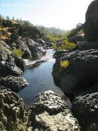
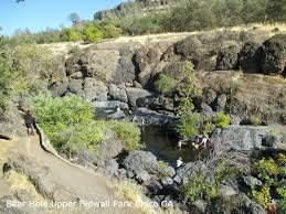
Add THIS to Your Bucket List: Swimming at Bear Hole in Upper Bidwell Park, Chico California. Crystallized Black Lava Rocks - Basalt from the Eruption of Mount Lassen.
Driving Directions: Go North on Highway #5 From Sacramento, California. Take a Right at Highway #32 (Orland) and Drive Thru Chico. Take a Left on Bruce Road. It Becomes Manzanita Ave. Take a Right on Wildwood Ave and Enter Upper Bidwell Park. Stop at Bear Hole and Walk...


Photos of Butte Creek Canyon California near Chico and Paradise. The Covered Bridge before it Burned. and Chico Creek's One Mile Swimming Pool...

On the Skyway to Paradise, CA
This Canyon is Famous for Gold Mining.

showing valley floor

looking towards Chico

another view looking towards Chico.


More Photos of the Covered Bridge
Before It Burned...
https://gvan42.blogspot.com/2018/10/the-honey-run-covered-bridge-over-butte.html
There is Now A Plan to Rebuild the Covered Bridge...
Millions of Dollars Donated to Build a BRIDGE TO NOWHERE!
https://krcrtv.com/news/local/new-honey-run-covered-bridge-gets-financial-boost
"One Mile" Swimming Pool in Chico California -
Bidwell Park - It's Located One Mile from Main Street...

Students "Horsing Around" at the pool

Students competing in a "fill up the bucket with a sponge race."

Three teams. A person runs to the pool, soaks sponge,
run back to bucket, empty sponge...
repeat with next team member...

much shouting needed... I Guess...

My Staircase... No Diving, so I just crept in Gradually...

When the Lifeguard is Present, no bicycle riding allowed... This Kid is taking advantage of the LACK of Law Enforcement to have a great time... Also, no smoking in the park... I lit up since there was no-one to enforce the rules.

Picnic Area 37. Redwood Trees.
These trees were brought from the coast where they are a native species and planted in Bidwell Park.
Note how the forest floor is swept clean...

Photo taken from within the Redwood Grove.
Note that the native trees are Not Redwood.

Train Depot Chico, CA

Caution: Don't stop on the tracks.

Mural...
https://gvan42.blogspot.com/2018/03/growing-up-in-los-gatos-california-in.html
My AutoBiography: Growing Up in Los Gatos, California in the 1960s by Gregory Vanderlaan - Chico, Washington DC, Eureka


.jpg)


%20(1)%20(1).jpg)


%20(1).jpg)

.webp)


.jpg)
