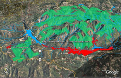
2005-2009 The California Department of Forestry ruled the logging plan ineligible... |
| Town of Los Gatos and Lexington Reservoir on the Left - Blue... Red Area Logging Area - Upstream to Lake Ellsman |
https://www.google.com/earth/outreach/success-stories/neighbors-against-irresponsible-logging-nail/
AUTHOR: REBECCA MOORE, NAIL
Neighbors Against Irresponsible Logging (NAIL) is a community group in California's Santa Cruz Mountains that formed after local residents received a legal notice in the mail about a proposed logging plan. The notice included the above black and white map which was prepared by a local logging firm and sent by the San Jose Water Company, which owns about 6,000 acres of watershed land in the region. The watershed provides drinking water to local residents as well as to over 100,000 Silicon Valley inhabitants. It also contains the county's largest remaining stand of coastal redwood forest.Many residents were puzzled by the map, which offered no clear distinction between roads, topographic contour lines and the plan area. It was so difficult to understand that many people simply threw it away, but NAIL member Rebecca Moore thought that the community might better understand the potential issues if she remapped the key elements of the proposal on top of 3D high-resolution satellite imagery in Google Earth. The visualization that Rebecca created changed community and policymaker opinion about the logging plan and eventually helped to stop the plan completely.
Two years later, the California Department of Forestry ruled the logging plan ineligible. Rebecca's pioneering work was a victory for environmental advocacy, and also showed that Google Earth can increase public awareness of community issues and facilitate real social change.
Rebecca Moore - Google Earth and Using Big Data to Map Solutions | Bioneers
https://www.youtube.com/watch?v=eTKmJhNjFGYhttps://bioneers.org/rebecca-moore-google-earth-and-using-big-data-to-map-solutions/
http://www.mountainresource.org/
The Mountain Resource Group is a non-profit organization based in the Santa Cruz Mountains of Northern California.
Neighbors Against Irresponsible Logging.
http://www.mountainresource.org/nail
SJ Mercury News: Neighbors use high-tech tools to challenge logging plan...
http://www.mountainresource.org/nail/blog/sj-mercury-news-neighbors-use-high-tech-tools-challenge-logging-plan
Armed with high-tech cameras, mapping software and a helicopter flown by a nemesis of Barbra Streisand, neighbors opposing a plan by San Jose Water Co. to log 1,000 acres in the Los Gatos Creek watershed claim they have found the plan's Achilles' heel.
Aerial photos and a detailed computer analysis show that the water company owns at least 2,754 acres of timberland containing redwood and Douglas fir trees, opponents said outside a public forum Wednesday.
That's a key number, because California law sets 2,500 acres as the maximum amount of forest land containing commercially viable trees that any landowner can own while remaining eligible for the kind of open-ended logging permit for which the water company has applied.
SJ Mercury Editorial Opposes Logging Plan
http://www.mountainresource.org/nail/blog/sj-mercury-editorial-opposes-logging-plan
Logging plan excessive for future of watershed
PUBLIC OWNERSHIP OF SITE SHOULD BE PURSUED AGGRESSIVELY
L.G. Town Council Studies Dangers of Logging in Mountains
The town of Los Gatos has stayed out of the controversy surrounding a proposal to log 1,002 acres of redwood and Douglas fir trees above the Lexington Reservoir. As the California Department of Forestry comes closer to completing its review of the proposal, the town has decided to take a closer look.
The timberland in question lies outside the town's jurisdiction. Last month, the town retained an environmental consultant to review all reports on a Nonindustrial Timber Management Plan that, if approved, would give Big Creek Lumber the go-ahead to log in perpetuity nine units of timberland owned by the San Jose Water Co. The environmental consultant hired by the town has been asked to determine whether the proposed logging would have any impact on Los Gatos.
http://www.mountainresource.org/nail/blog/lg-town-council-studies-dangers-logging-mountains
https://www.youtube.com/watch?v=0-_I-0Mv2DI&feature=youtu.be
A flyover of the Area...
http://web.archive.org/web/20111111030545/http://www.sierraclub.org/sierra/200709/google.asp
Sierra Magazine:
Eyes in the Sky and on Your Desktop
With Google Earth, satellite images become an activist's ally
By Gregory Dicum
September/October 2007
LATE IN 2005, REBECCA MOORE WAS GIVING a presentation to a community group concerned about proposed logging in the Santa Cruz Mountains, south of San Francisco. In the darkened room, a large screen displayed an image of Earth floating serenely in space.
 |
| Lexington Reservoir - Blue Proposed Logging Area - Red |
Moore touched a key on her computer, and the planet expanded to fill the screen. As the view zoomed closer still, the more than 300 audience members were able to make out the California coastline, then their own region. The landscape tilted, and the flat imagery leaped up to form mountains and valleys. Finally, they could see detailed three-dimensional satellite images of the redwood-covered ridges above their homes.
Moore touched another key and added an overlay of the proposed logging plan. The audience gasped. Suddenly, the grainy sketch a timber company had presented as a fire-prevention measure was revealed for what it was: a commercial logging operation that would deplete the forests adjacent to the community's homes and schools and threaten the drinking water of more than 100,000 people.
"It electrified the room," recalls Moore, who had developed the presentation in just a few days using Google Earth, a free desktop application that lets anyone with a modern computer explore a breathtakingly detailed digital model of the planet.
~~~~~ On Facebook, a Friend stated: ~~~~~
Eric Elric Horton Hi Gregory, Rebecca was one of the early members if the steering committee.
It actually went until 2008/2009. We ended up with a hearing in the Capitol at the Board of Forestry. It was amazing to be involved with such a dedicated group of people.
Here is the beginning of a documentary I started directing about it...
https://m.youtube.com/watch?v=PSDGRpH7Tn4&feature=share
Link to a Google Image Search
for all my artwork!
~~~~~~ (~);-} ~~~~~~
and Now, on a Different Subject...
~~~~~~ (~);-} ~~~~~~
Find more FREE COLORING BOOK ART!
at Google Image Search
using the Keywords: gvan42 free coloring book
or click on this link!
YOU MAY READ MORE BLOG POSTS ON SIMILAR
SUBJECTS BY USING THE HANDY LABELS BELOW...
Click and Enjoy the Bliss!


%20(1)%20(1).jpg)


.jpg)