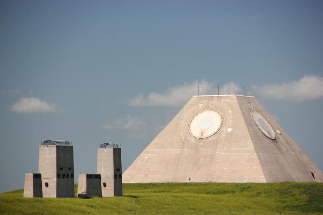
The Stanley R. Mickelson Safeguard Program was developed in the 1960s to shoot down incoming Russian intercontinental ballistic missiles.
 |
| The circles on the Pyramid are RADAR Sensors |
 |
| Nekoma, The Nuclear Missile Defense Radar Pyramid |
https://srmsc.org/dps2030.html
More Photographs and History: https://srmsc.org/
A Video: https://www.youtube.com/watch?v=onDZLKie1Fg
For almost half a century, from the end of World War II until the fall of the Soviet Union, our world existed on the precipice of nuclear annihilation. The threat of an instant and irreversible descent into nuclear war hung constant over our heads, the pendulum of power sometimes swinging our way and sometimes back toward the Soviets. It was this race for superiority that led to the creation of this place, the most advanced nuclear antiballistic missile facility ever built. This is the Stanley Mickelsen Safeguard Complex in Nekoma, North Dakota. See more content like this at http://GhostsofNorthDakota.com
Myths of Nekoma - The Pyramid of North Dakota and the Stanley R. Mickelsen Safeguard Complex
Stanley R. Mickelsen Safeguard Complex...
The Stanley R. Mickelsen Safeguard Complex (SRMSC) was a cluster of military facilities near Langdon, North Dakota, that supported the United States Army's Safeguard anti-ballistic missile program.[1] The complex provided launch and control for 30 LIM-49 Spartan anti-ballistic missiles, and 70 shorter-range Sprint anti-ballistic missiles.
The deployment area of the complex covered the Minuteman launchers of the 321st Strategic Missile Wing, based at Grand Forks Air Force Base, North Dakota. Under the terms of the 1972 Anti-Ballistic Missile Treaty, the US was permitted to deploy a single ABM system protecting an area containing ICBM launchers. The total of 100 launchers and 100 missiles was the maximum permitted under the treaty.
Many more pictures at:
https://www.coldwartourist.com/stanley-r-mickelsen-safeguard-complex
~~~~~~ (~);-} ~~~~~~
a Similar Site:
Mount Umunhum Radar Tower.
Near San Jose, CA
The Red and White Dish Rotated Constantly.
https://en.wikipedia.org/wiki/Mount_Umunhum
Phone Book Cover -
Mount Umunhum Radar Tower
Since the Radar Tower Was Easily Visible from All Over San Jose... Millions of People Lived for Decades with it... The US Military Always Protecting Us from Nuclear War... and it was a Constant Reminder that we were THREATENED by Nuclear War...
After the Cold War Was Over the Red and White Spinning Radar Element was Removed... and NOW it's a Park. Popular with Bicycle Riders...
https://hilltromper.com/article/mt-umunhum-radar-tower-midpeninsula-open-space
https://www.sanjoseinside.com/news/cold-war-tower-receives-historic-designation/
Santa Clara County deemed a Cold War-era tower atop Mount Umunhum a historic landmark Tuesday after months of debate over whether to preserve or raze the giant concrete cube.
In a unanimous vote, the Board of Supervisors added the several-story structure to the county’s Heritage Resource Inventory, a designation for historically important structures. The new ordinance also means that to demolish the tower would require a special permit.
“The Cube,” as it’s often called, was built in 1962 to detect enemy aircraft when the property served as an Air Force station.
"The Radar Tower is a captivating sight from the valley floor and one of the things that many remember most when looking at the mountain tops around Santa Clara Valley," said Supervisor Ken Yeager. "It's important that we preserve relics of our region's military history."
http://www.redwoodhikes.com/Skyline/MtUmunhum.html Hiking Instructions...


.jpeg)


.jpg)


%20(1)%20(1).jpg)


%20(1).jpg)

.webp)


.jpg)
